Snow & ice
Expected accumulation and freezing precipitation signals

Live school-closure forecast
Use a free snow day predictor for U.S. and Canadian locations, with live snowfall, ice, temperature, wind and hour-by-hour storm timing. U.S. results also check active National Weather Service winter alerts for official context.
Live forecast estimate
Enter a location to compare tomorrow's snow, ice, temperature, wind and morning timing.
Focused winter checks
The main school-cancellation estimate covers snow, ice and extreme cold together. Use a focused page when you need the assumptions and limits for one specific setting or hazard.
Start with the College setting and interpret weather pressure alongside the campus's official operating notice.
Open calculatorInspect the near-freezing rain signal, temperature, timing and separate official weather-alert context.
Open calculatorSee how forecast temperature and wind chill contribute to tomorrow's school-closure estimate.
Open calculatorMore than a snow total
A storm's timing and road impact can matter as much as its total. Our published methodologyexplains every weight and limitation.
Expected accumulation and freezing precipitation signals
Snowfall during the bus and road-treatment window
Temperature, wind chill and blowing-snow pressure
Area type, school level and district sensitivity
Planning tool, not an official notice. A percentage cannot see every bus route, staffing issue or last-minute road report. Active NWS winter alerts are shown separately and do not change the percentage. Read the full accuracy and limitations guide, see who builds and maintains it, then confirm with your school district.
Six questions behind the forecast
A useful school-closing estimate explains why the number moved. These are the six practical questions to review before making a backup plan.
A snow total is only a starting point. Heavy snow, wet snow, freezing rain and a light glaze create different transportation problems. The model keeps snow and a cautious near-freezing rain signal together, then shows the underlying forecast values so you can see whether accumulation or possible ice is driving the result.
The same snowfall can produce a different school response depending on timing. Snow that ends early gives crews more time than snow intensifying during the morning bus window. The result therefore separates the previous evening, overnight period, 5–9 a.m. transportation window and normal school hours instead of relying only on a daily total.
Temperature affects precipitation type, melting and the possibility that wet surfaces refreeze. A forecast hovering near 32°F can be more complicated than a steadily colder, all-snow event. Read the minimum and maximum together, and remember that this calculator does not measure pavement temperature or conditions on an individual bridge, hill or sidewalk.
Wind can raise exposure concerns at bus stops and can move loose snow back across treated roads. Wind chill is calculated from forecast temperature and wind when the standard formula applies. It adds cold-weather context, but it is not a promise that a district uses a particular numerical threshold or that travel is safe below one.
Urban, suburban and rural systems often face different route lengths, hills, transit dependencies and treatment schedules. The area selector provides broad transportation context; it does not claim to know each bus route. Choose the setting that best matches the school network, then verify real road information through local transportation and emergency-management sources.
Elementary, middle, high school and college operations do not always respond in the same way. The selected school level supplies a small sensitivity adjustment, while the district-tendency control moves only a non-zero weather estimate. Neither option can turn a clear, mild forecast into a credible cancellation, and neither replaces an official announcement.
Quick location checks
Local readiness changes the meaning of the same forecast. Each city page below loads its own coordinates and explains what actually drives a closure there, which is why closure thresholds differ by region.
Browse the hierarchy
Winter weather and school authority are both regional, so the site is organised that way. A regional hub explains the pattern; a city page applies it to one location.
Regional hubs covering the Great Lakes snowbelts, the Northeast coast, the Ohio Valley, the Upper Midwest and the Front Range.
Metric by default, with the bus-cancellation-first reality of Canadian school decisions explained rather than glossed over.
A better checking routine
The chance of a snow day tomorrow becomes more useful when you know what to do at each stage. Used as a snow day checker rather than a verdict, rechecking is not chasing a number; it is responding to newer weather information.
Use the five-day view to see whether a winter-weather period is emerging. At this range, storm tracks, temperature boundaries and totals can still move. Make flexible plans, but avoid treating an early number as a final school forecast.
Check tomorrow, read the factor breakdown and compare the overnight and bus-window snowfall. Arrange possible childcare, transportation or remote-work options. For U.S. locations, open any displayed National Weather Service alert for the official hazard details.
Forecast guidance and alerts can change overnight. Run the location again, note whether precipitation type or timing shifted, and check the district's website, message system or verified social account. The official school notice—not the calculator—is the final answer.
A district may choose a closure, delay, bus cancellation, early dismissal or remote-learning schedule. Those outcomes are not interchangeable. Read the entire message, confirm the date and affected schools, and use official weather or transportation advice for any travel decision.
Want the reasoning in more detail? Read the guide to the best times to check a snow day forecast and our explanation of how schools make the final decision.
Know what the location search covers
The calculator accepts cities, U.S. ZIP codes and Canadian postal codes. Forecast coverage is broad, but school policies and official-alert systems remain local.
A U.S. location receives the live forecast estimate and a separate check for active National Weather Service winter alerts. The alert headline, affected area and official forecast link are shown beside the result when available. Alerts are important safety context, but they do not secretly add points to the published six-factor percentage.
Canadian searches use metric display units by default and the same transparent weather model. Government of Canada alerts are not currently loaded inside the result, so check Canada.ca/weather, the local school board and the transportation consortium directly. A board closure and a bus cancellation can also be separate decisions.
No national calculator can observe every road, plow, bus, building or staffing issue. Two neighboring systems may react differently because their routes and policies differ. Use the percentage to prepare, use the factor rows to understand the weather, and use the authorized district or campus message to learn what is actually happening.
Compare the evidence, not the slogan
No public calculator can see the district's final decision in advance. A stronger tool earns trust by showing its data, method and uncertainty clearly.
A percentage is difficult to evaluate when the page does not identify its forecast source or observation time. This calculator names Open-Meteo, shows when the forecast was checked, displays snowfall, temperature, wind and precipitation probability, and links supported U.S. users to the official NWS forecast. You can inspect the conditions behind the estimate instead of accepting a number without evidence.
Useful prediction tools explain which inputs mattered and how much weight they carried. Here, all six factors appear in the result with their values, score bars and published weights. The hourly panel also reveals whether forecast snow is concentrated overnight, during the morning bus window or later in the day. Changing display units never changes the underlying percentage.
Weather forecasts contain uncertainty, and school decisions contain additional human and operational information. Be cautious with any service claiming universal perfection or implying that a low closure chance makes travel safe. This site publishes what the model cannot observe, keeps official alerts separate from the score and repeatedly sends users back to the authorized school and safety sources.
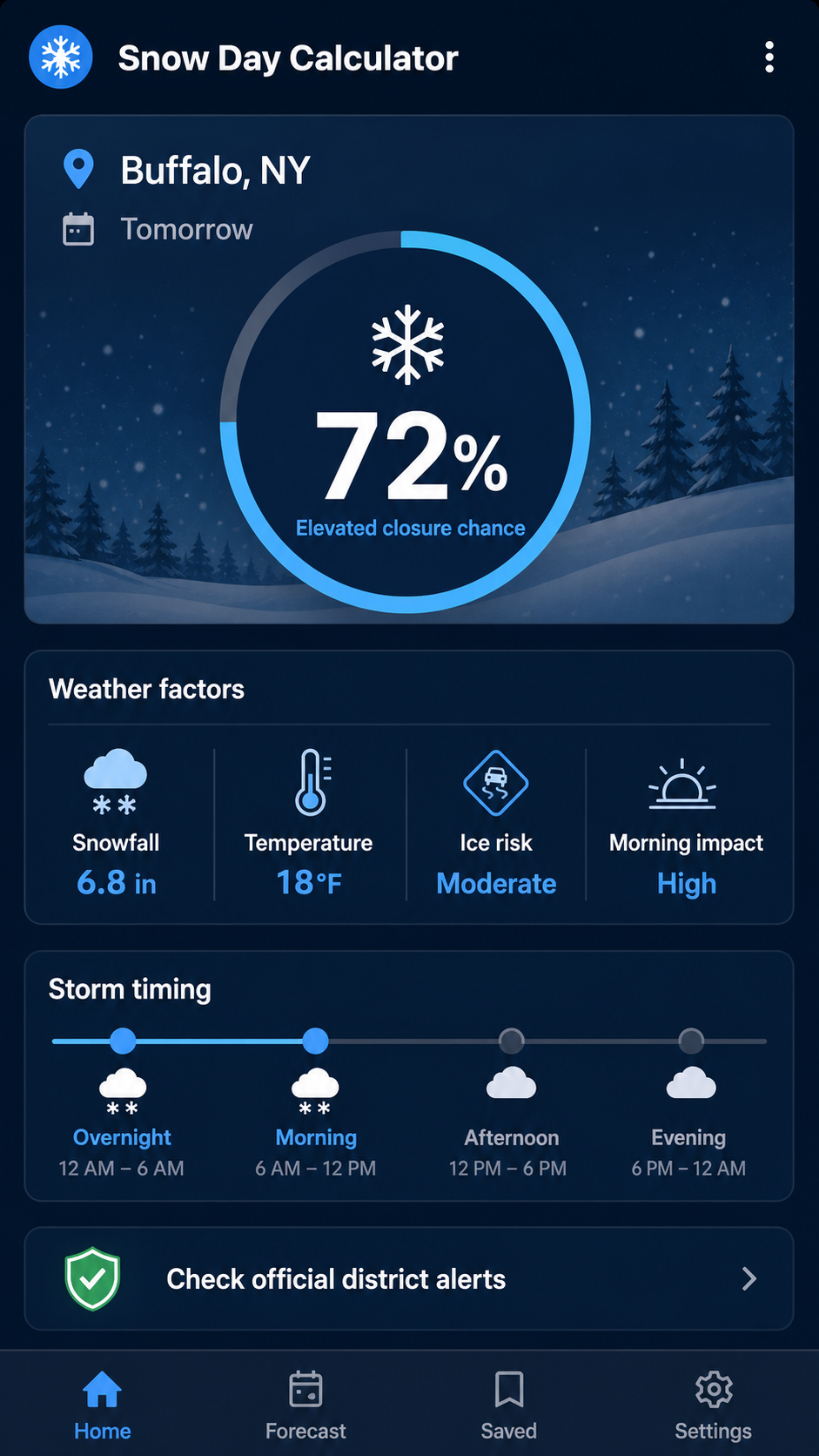
Mobile companion
The mobile workflow is designed for quick location entry, a clear percentage and a factor-by-factor result. See what to compare when choosing a snow day predictor app.
Decision-ready reading
Quick answers
A useful estimate should show its inputs and admit what it cannot know. For deeper answers, visit the snow day calculator FAQ.
No. It is a weather-based planning estimate. Only an authorized school district, board, college or university can announce a closure, delay, bus cancellation or remote-learning schedule. Always confirm the date and affected locations in the complete official message.
Use a several-days-out result only for awareness. Check again in the evening to prepare, then refresh the forecast and official district channels early in the morning. A changing percentage is expected when forecast snowfall, precipitation type or timing changes.
Bus routes, hills, road treatment, staffing, building conditions and local policy can differ even under the same storm. The area and district-tendency settings provide broad context, but they cannot reproduce every local operational decision.
No. “High” means that the forecast strongly favors disruption in the published model. A district may still delay, cancel only transportation or remain open. Treat the result as a reason to prepare and monitor—not as permission to announce an outcome.
No. The calculator is not a road-safety tool and does not observe pavement, bridges, crashes or treatment progress. Follow official weather alerts, transportation agencies and emergency management for safety information, even when the school-closure estimate is low.
Yes, but with clear limits. It uses a cautious near-freezing rain signal rather than a road-ice sensor, and it scores temperature and calculated wind chill separately. Use the focused ice-day and cold-day pages when either hazard is the main concern.
Yes. Select College—or open the college snow day calculator, where that setting is already chosen. Then compare the weather estimate with the institution's emergency-alert system because class cancellations, campus closures and essential-service operations may differ.